Flashback: the 1979 Wind River Expedition
hike home pg Wind River I Taboose-Whitney Pine Creek Defeat Pine Creek Revenge Mono Pass loop Wind River II x-c extravaganza Piute-Lamarck PNW hikes e-mail Jim

I fell in love with backpacking in late 1973. I made my own mountain tent (well, my mom helped a ... lot), bought a magnesium-frame pack and some dehydrated food at K-Mart, planned routes around Glacier Peak in Washington and generally immersed myself in hiking books. The Eric Ryback books were fascinating, and even when rumors of their accuracy surfaced I ignored such details and looked again at the maps and pretty pictures. The images of Evolution Valley and Forester Pass in the Sierras sounded superhuman to me, and in fact were well beyond my 16-year-old skills. The later Ryback book about the Continental Divide showed me other amazing places, and the photos of the Wind River Range showed me mountains doing things I'd never seen before (I was far more accustomed to cinder and basalt than white cliffs of granite). I didn't make much use of my equipment, but I exercised my enthusiasm on countless occasions, with books and maps assisting me in my mental journeys.

As a college student in 1979 I occasionally drifted into Portland State's outdoor-program lounge. The most notable and popular event was the tour of the Blitz-Weinhard brewery. I was filling in some credits in summer term when I opened the school newspaper and read about the latest in campus life. My heart nearly stopped when I saw the upcoming schedule of the outdoor program: a week in the Wind River Range! Another week in the San Juans of Colorado!! Both sounded interesting, but the Wind River images were irresistible; I signed on for the early-September excursion and sat in on the discussions. Jerry was the group leader, and he looked like a serious outdoor person - full beard, strong build, good high-altitude tan. He sketched out a five-day tour that included the Cirque of the Towers, a granite amphitheater surrounding Lonesome Lake high in the southern Wind Rivers. I loaded up my pack and started taking it everywhere, getting in shape for the trip.

At last the departure date arrived. The outdoor program was using a new school van that had only a few hundred miles on it; that would change in no time. Our group of six (Tony, Francin, Ken, Robin, Jerry and I) would take turns driving from Portland to Wyoming during the night to get us more quickly to the mountains. We started at 9pm; by early afternoon we were in Jackson, Wyoming, where we picked up more maps and other last-minute items. We ended the long day near Pinedale, at a campsite along Fremont Lake.

The next day found us dodging cattle on the back roads and admiring the distant peaks that drew ever closer. By late morning we were putting on the packs for a group photo and leaving the van behind us. I took a calculated risk at the end, leaving my homemade mountain-tent in the car; it was cute and effective, but Heavy. The first day was a short one, but I wasted no time in acquiring a healthy blister on each foot; the foot-soak in the Big Sandy River felt wonderful that day! We camped at Big Sandy (that name again!) Lake, and I ate some of the food I bought back in '73 (edible, but nothing special). We had just turned in when a quiet rustling in the bushes took form as a gang of mice, storming our fort in search of food. One ran across my chest; when I sat up to look, another ran across my pillow. We grabbed our food-bags and hung them out of reach; after that, the mice cleared out and let us sleep.


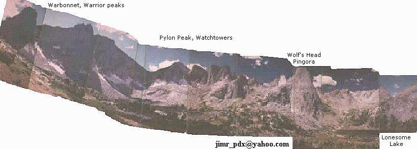
Cirque of the Towers panorama


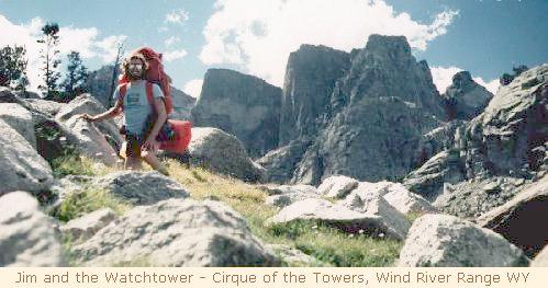
Jim in the Cirque of the Towers

Day two of the hike found us following the Big Sandy River above the similarly-named lake, with a good view of Big Sandy Mountain on our right. The hikers settled into their normal paces, meaning Jerry disappeared in a cloud of dust, with Robin occasionally visible in the far distance. Ken and I generally stayed close, with Tony and Francin just behind. After a scenic drop to North Lake, the climbing began again with sharp peaks appearing to our north. Some maps indicated that we were heading for Big Sandy Pass (no surprise) while other maps showed Jackass Pass. We all met for lunch on Big Sandy Pass, and more group photos ensued. While photographing a pile of granite at close range, my shoulderstrap separated from the camera and sent it on a three-foot drop to oblivion. I frantically examined it while we resumed hiking, hoping to bring it back to life by fiddling with every moving part (the lens had not been damaged). We dropped down to Arrowhead Lake (well named!), then climbed again to ... Jackass Pass. Both maps were right, but no map had both passes marked. Lonesome Lake now showed up, as did a few grey cumulus clouds. While messing with the camera I flipped the shutter speed to 'bulb' - something went "thunk" - and all was well again!! Pleased with my good fortune and stunned by the scenery, I stood in place and shot the entire Cirque of the Towers from SSW to NE, and shot an entire roll of film in about ten minutes. (This was the trip where I decided that owning a wide-angle lens would be a good idea; all photos were with a standard 50mm lens, hence the multiple shots.)

We reached a lovely campsite below Lonesome Lake, took off the packs and each relaxed in our own ways. I wanted to see Texas Pass on the north side of the Cirque, but no one else was interested. Tony and I decided to follow the lake's inlet stream to the very base of the Towers, and found a tiny lake surrounded by exfoliated granite slabs; it was an amazing place. A few raindrops fell on us as we passed the small waterfall above the lake, and we reached camp and discovered that Jerry was gone. He became tired of the camp scene, grabbed his camera and climbed up to - yes, to Texas Pass. His pictures of that view were so amazing that I bought a copy of the slide; looking south toward all the Big Sandy Stuff was incredible from his high perch! Our camp was unmolested by mice, but several interesting events took place that I missed. Robin slept on a large granite slab surrounded by a meadow, and was awakened early by a deer that grazed to within feet of her site. I awoke early and shot the full moon setting over Pingora spire, remembering later that a lunar eclipse took place during that night... ouch!

Day three was an ambitious one, and would set a new personal high-elevation mark. Now in the Popo Agie Primitive Area (a notch below Wilderness!), we followed the North Fork Popo Agie downstream a mile or two, then turned left on the Lizard Head trail. Jerry rested against a sign, which he revealed to us when we all caught up with him. It was a rather large sign, warning us to be alert to bears. Thankful for the reminder, we began ascending a stepladder of a trail which carved itself into the rock wall, transporting us rapidly from just under 10000' to around 11500', We stopped for snacks and enjoyed the excellent view of the Cirque of the Towers and another impressive formation due south of us which included Dogtooth Mountain and the Monolith. The trail crested at 11880 feet and revealed the odd nature of the Wind Rivers. The entire range was lifted high, then heavily eroded by ice and weather; viewed from on top, the mountains all appeared flat with deep ravines carved out of them. We walked for miles on tundra above 11500 feet, looking down into various valleys where living things lived and played. It would have been a brutal spot in bad weather, but sunshine and wind kept things pleasantly cool. 'Primitive Area' has meaning here: the trail was extremely faint, and only by watching for rock cairns could one actually keep to the route as it wound over Cathedral Pass and down to the Bears' Ears trail. I found the song "Lonesome Loser" helpful in crossing the pass, as its steady beat kept my feet moving when my energy level faded. Finally dropping off the crest, Tony and I found that the cairns had failed us (or we them); we had no clue how to get down to the valley again. We improvised our way down a few steep talus slopes and finally saw the trail again. It was quite late when we collapsed at Valentine Lake, where Jerry waited for us. Ken and Francin were still behind us, and Robin pressed on to a more distant lake, so we were strung out in more ways than one. Just to be sure no one stayed solo Tony pressed on to catch Robin while Jerry and I waited for the others. Ken and Francin arrived just short of dusk: they had also lost the trail, and had to retrace their route after encountering a sheer drop. We continued on but darkness caught us at the South Fork of the Little Wind River, where strong winds drove us under a thick clump of trees for the night. From that angle it was clear why the peak to the south was named Buffalo Head!
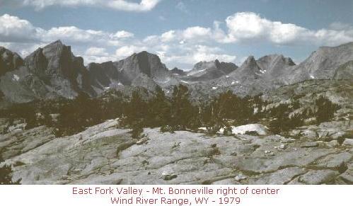

East Fork Valley

The fourth day found us still in two separate groups. Our foursome struggled to cross the stream, finally jumping across in several spots. I jumped back to help Francin get across, putting on her pack to simplify her task. At that moment I experienced a revelation: backpacks CAN be comfortable!! Her Alpenlite pack was such a joy to wear that I hated to give it up. It probably weighed less than mine as well, but the way it conformed to my movements was so pleasant that I resolved to seek one out as soon as I returned to Portland. Passing the Washakie Lakes on our way to Washakie Pass, I took the lead for the first time and challenged myself to reach the top first. As I passed a few last tarns I saw the finish line - and heard the thin scream of strong winds racing over the pass. I claimed a strategic victory there and sat down, eating lunch and preparing for a strong wind in the face. The other three joined me, Jerry wondering where Tony and Robin had gone. In fact they slept late that morning; we had passed them at Washakie Lake and missed their subtle marker. He stayed on the pass while Ken, Francin and I crossed into the gale, looking west into the Pacific drainage and lowering stratus clouds. That afternoon was an endurance march under the strong winds, but the view north toward Raid and Ambush peaks left me wishing our trail had gone that way. Stumbling down a narrow defile, we reached Marms Lake late in the day and endured a spattering of rain while we prepared camp (easy to do with no tent). The other three arrived later, and Ken went fishing for a while in the early evening. A thunderstorm rolled by later, echoing down the granite canyons north of us; more splatterings of rain made me aware that even heavy tents have their value. I pulled my raincoat over my head for five minutes, then the rain would stop for ten minutes, then return to complete the loop.

The last day was ridiculous in its simplicity. No more passes, peaks or cirques to visit, just travel down a long meadow for several miles to the van. I discovered some new hiking songs with faster pace (notably from Pink Floyd), and I switched into tennis shoes for the soft and easy trail. I burst into the lead and never gave it up. A large flock of sheep was moving through the meadow, acting strangely at times; as I drew closer I saw that they were climbing over the occasional granite slab in their way instead of walking around them, so now and then a sheep would appear five feet tall, then sink into the crowd again. A short time later I startled a few quail on the trail; I took a picture and continued on. At last the van came into view, and (more important at the time) a pit toilet. After availing myself of the high technology, I found the others had arrived. Another group photo was taken, followed by the Dipping of the Beer. I had left two 8oz. cans of Coors in the van, and I dunked them into the chill waters of the (surprise) Big Sandy River for about ten minutes. I have experienced many others since that day, but that drink still stands out as my Best Beer Ever.


Epilogue:
After changing into spare clothing, we hit the homeward road. That night was spent at Jackson Lake in the Teton national park, making full use of the pay showers. The following day we cruised through Yellowstone Park, visiting the geyser basins and waterfalls before heading north to Interstate 90 and another tag-team drive home. Dawn found us between Ritzville and Pasco, and by mid-afternoon I was sitting at home, wondering what to do with myself. That was the most disorienting post-hike event I can remember - and I've had a lot of other disorienting times in my life, too! I'm not sure what most of the others did next, but I know Jerry cleaned up himself and the van -- and drove to the San Juan mountains for another week of adventure.

As I recall, most or all of us met for a big slide show by Jerry and me (did others have cameras?). I don't think I saw any of them again except Robin; we talked for a while in the outdoor program room one day just before she moved away from PSU. Where are they now? Perhaps their stories are in cyberspace too! If not - they should be.


1998 Wind River Range encore!