| NOTE! This page goes into route details from our trip. If you prefer to know only sketchy details about this area, step away NOW! |
|---|
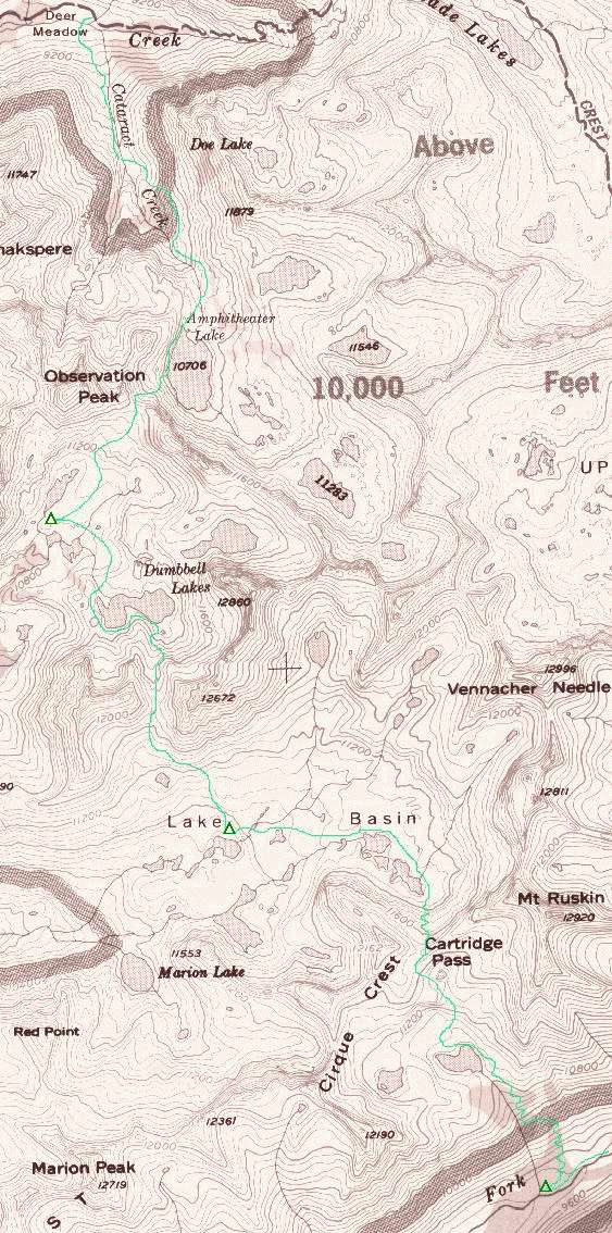
Our cross-country tour begins on day two, along the South Fork Kings River. By heading downstream from the JMT where it crosses the South Fork, we picked up the path within five minutes. It comes and goes through downed trees, talus and fast-growing meadowlands. The third patch of talus, and the largest, ends just east of the wooded rise that culminates in the Cartridge Pass lake basin. As DW Donehoo noted to me, a small meadow can be seen through the trees; the South Fork bends left but the meadow was pretty much straight ahead off the talus. The trail never gets reorganized beyond the talus; we hunted a while for it but were pretty exhausted, so we camped a bit further down-river near where a small creek enters the South Fork.
Once at the lake the path faded, but after climbing above lake level we saw it again near shore. This is probably NOT the direct route, but we descended to it and followed it until due north of the lake, where we aimed NE and soon recovered another path winding up from somewhere above the east side of the lake. This path climbed to near the highest rockbound lake, then turned due west to the top of a small rise. From there the path turned north, and finally northeast again, to just east of the low point of the pass. The lowest point was snowbound in '99, somewhat surprising in such a dry year.
The route down the north side was entirely made of steep, loose scree, and the switchbacking path has been severely damaged by other previous travelers that took a more direct route. Our advantage of seeing this part of the trail from above was therefore lessened, and we took whatever path seemed most developed while still minimizing the risk of free-fall. After a tough half-hour or so we were on relatively level ground again, following a clear path east of the upper lakes. Shortly after this we lost it again and headed north to regain it; in hindsight it's clear that the path veered west here, not north, but travel was uncomplicated until the bench just above the northern L-shaped lake. We scrambled down with little trouble and camped at a good site by the lake, just below the notch that becomes Dumbbell Pass.
Scott surprised me at the bottom of Cartridge Pass. When I asked him how much money it would take to make him cross the pass again, he started the bidding at a cool million. For myself, I figure a year's wages would have been sufficient!
At the narrow part of the high lake we changed into rain gear, which helped cut the freshening breeze. The lake was displaying a maddening tendency to turn left, so each time we rounded a bend we found still more water in front of us. Checking the 15-minute Mt. Goddard topo map showed a contour line brushing against the southern shore of the lake's western lobe, and it proved to be distressingly accurate. We found ourselves physically and mentally exhausted, in dubious but dry weather, confronted by a class-three cliff that blocked our shoreline path. Two minutes of sheer adrenaline-rush followed as we grabbed some well-placed cracks in the granite, hugged the wall, and lowered ourselves five feet onto a narrow shelf that eventually led down to the water's edge. After another well-earned break, we were nearing the end of the agonizing journey around the lake at last!
Having finally reached the outlet stream, we rested and examined the valley for a good camp that would not cost us much elevation. We set out north toward the largest trees in sight, but they were insufficient for protection from the elements. We continued on to a point near the end of the long northernmost lake, where whitebark pines and level ground combined for some great campsites. It felt very good to put down the packs, and the Dumbbell Lakes basin was a beautiful sight even in the raw, but still dry, evening. Looking back at the west side of the uppermost lake, it's not at all clear that staying above the lake from the pass would stay anywhere near class two; the route we took was uncomfortable but not unduly punishing.
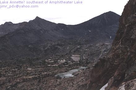
The route we took went left, dropped swiftly, then cut across the snowfield at a relatively level spot where the snow followed two ways around a large rockpile. Now right (ESE) of the snow, we went left over moderately large talus and aimed for a patch of green that from here appeared to overhang the lake. The high lake SE of Amphitheater Lake sparkled in the beautiful valley, and I dropped my pack and fished out the camera to capture it. Once we reached the green patch, I shot a picture back the way we came, then moved right and down a short way, then switchbacked down to the shore, where more large talus awaited. With plenty of recent experience under our belts, we negotiated our way above the shoreline, and finally dropped our packs by the lake after two hours' hard work. We were amazed at how anyone decided that this was a functional route; from the lake it appears to be a minimal, snow-choked notch leading nowhere.
The Secor book stated that travel from Amphitheater Lake to the old path below was 'easy'...
| WRONG. |
|---|
We crossed the creek just below the pond over plentiful talus, then followed the path for nearly ten minutes before losing it. As with previous paths, we picked our route as seemed best, then recovered the path a few minutes later. As we began to reach the more thickly-forested regions, though, it went away for keeps. This was a beautiful area, with the babbling stream accompanied by several species of pine, fir and mountain hemlock; a bit further down the aspen joined in. We stayed near the west side of the creek, even though the old trail may have been west of us, but we found a game trail or two that served us well. That service ended within sight of Palisade Creek, where a large field of fallen trees intervened. We were extremely weary of talus-hopping, but it seemed fun compared to the snags, brush and hidden rocks we blundered through in midafternoon. When we finally passed this final test, we shocked our feet by crossing chilly Palisade Creek, then gave them a rest at a fine campsite on the south side. Our extreme cross-country adventure was within 100 yards of completion, but we rested a half-hour or so before heading north to the Muir Trail. It was around 3:30, and our schedule strongly suggested we make a few more miles before ending the day. We finally called it a day at the Middle Fork Kings, joining two other couples at the large camp area where Palisade Creek meets its end
| TRIP SUMMARY | PHOTOS |
|---|---|
| Back to the Beginning.. | |
