|
DAY SEVEN
was both spectacular and difficult due to a poor night's sleep. My bedroll was on a slope, so my feet became chilled until I reversed my sleeping position. Soon thereafter I noted a rather thick frost forming on the bag; while the bag kept me warm and dry through the night, the frost was heavy and distracting, costing me more sleep. I awoke groggy and grumpy, setting me up poorly for a full day's hiking.
We first climbed north to Division Lake, still slumbering in the shadow of its cliffs. A zig east to Regiment Lake was followed by a zag above Ram and Ewe Lakes - and then it hit me. Directly in front of us loomed Mt. Reinstein, a goal even more enticing than Valor Pass ! I tried to ignore its siren song , but it kept working on me. Trouble is, a group of three doesn't divide well at all, and Frank wasn't smitten by Reinstein's song, so after an internal struggle I postponed the climb until later. Dropping to Bighorn Lake we veered eastward again, up to impressive Ambition Lake. While the route didn't look appealing from here, we followed the topo map's guidance northeastward and found a good route to Valor Lake, from which any short walk north or east leads to a steep drop to uppermost Goddard Canyon and Martha Lake. Within twenty minutes we stood on the brink and looked about in amazement. , but it kept working on me. Trouble is, a group of three doesn't divide well at all, and Frank wasn't smitten by Reinstein's song, so after an internal struggle I postponed the climb until later. Dropping to Bighorn Lake we veered eastward again, up to impressive Ambition Lake. While the route didn't look appealing from here, we followed the topo map's guidance northeastward and found a good route to Valor Lake, from which any short walk north or east leads to a steep drop to uppermost Goddard Canyon and Martha Lake. Within twenty minutes we stood on the brink and looked about in amazement.
|
WHAT A VIEW. First and foremost stands the dark sentinel of Mount Goddard, with cliffs strewn about its eastern flanks to guard the summit 1600 feet above. Directly between and nearly 1000 feet below us, Martha Lake marks the start of the San Joaquin's south fork, and Goddard Canyon drew our gaze northward. Goddard's satellite peaks, clad in both dark and rusty red rock, were equally intimidating in appearance, blocking views of adjacent valleys. Amazingly enough, through a gap to the northeast a still-larger peak revealed itself: Mount Humphreys is a distinctive peak from all directions and showed itself unmistakably even from this distance. It was not the only distant peak, though, with Seven Gables and Gemini standing tall above the east wall of Goddard Canyon, and Black Giant poking up just to Goddard's right. Mt. Reinstein covered the skyline to the southwest, while Scylla and the Ragged Spur presented another dark face to us. Since my buddy Scott was planning to reach Ionian Basin from Martha Lake, I tried to record on film and tape my impression that his proposed route, while feasible in guidebooks, was not something I would ever tackle. While trying to relax from the top of our lighter granite outcrop, I flexed my now-tender right ankle: it was telling me that, after Valor Pass, Mt. Reinstein was now out of reach. The lack of sleep, sore leg and failure to climb that peak combined to increase my grumpiness and lessened my enthusiasm for the awesome view. I consoled myself with a few self-photos at the top, my bandana wrapped like a pennant to the top of my hiking-stick. It was no Himalayan prayer-flag, but the wind whipped it nicely as I rested at the high-point of our trip (just under 12000 feet).
|

Mt. Goddard over Martha Lake
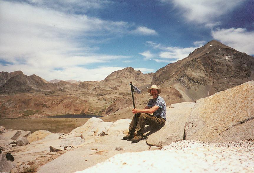
Valor Pass - Hunphreys left & way back
| |
| |
After a long look over the absurdly steep ledge (so steep that after a few minutes I got spooked and had to move back!), it was time to return to camp. we retraced our steps down to Ambition Lake, where another route to Reinstein was available. The ankle reminded me that camp was the best option, so I reluctantly continued back to Bighorn Lake. From just above that lake the entire expanse of Blackcap Basin comes into view, with lakelets and tiny meadows strewn at the feet of its namesake peak. From the lake we took a new path toward Division Lake's outlet stream, pausing at the low divide for another wonderful view of Finger Peak to the south. Pearl Lake retured to view, and after crossing Division's stream and yet another low ridge we were back in camp. After slipping into more comfortable shoes, my first task was to find a flatter campsite and pitch the rainfly. The weather promised to be as good as the night before, but I wanted no mroe frost on my sleeping bag. After another fine dinner, we waited for the sunset (beautiful, but no alpenglow spectacle) and slept soundly in preparation for our two long days back to civilization.
|
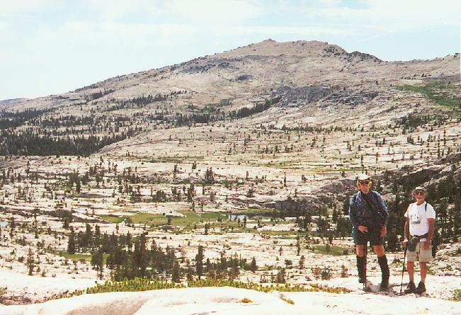
Blackcap Mtn, Frank, Del
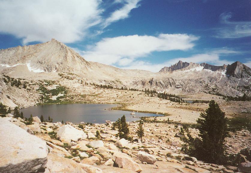
Division and Pearl Lakes, Finger Peak
|
|---|
|
pre-hike -
day One -
Two -
Three -
Four -
Five -
Six -
Seven -
Eight -
Nine -
Summary
|
|
