|
DAY FIVE
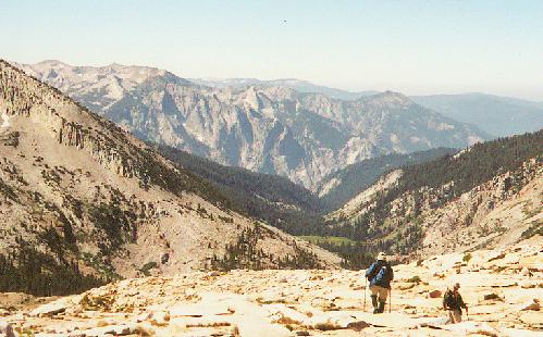
had mutated from the original 'plan'. What had been a tough packing day over Mantle and Blue Canyon Passes would now be a full day-hike to Blue Canyon Pass and back - much more relaxing and easier on the legs. My left knee was saying unpleasant things about the trip so far, so a light day with an Ace bandage seemed like a fine idea. The day-pack was full of foul-weather gear, just in case. By leaving camp intact we were able to start early, and an hour after starting we reached the final climb to Mantle Pass. Two options present themselves here, and Del took the direct route while Frank and I took the grassy slot to the north. Both proved uncomplicated, and we met by the shore of the unnamed lake on the east side. Nearly a dozen birds were chirping merrily here, prompting me to suggest Songbird Lake as its name - a good complement to Hummingbird Lake on the other side. We stayed pretty close to 11000 feet as we crossed into uppermost Blue Canyon, and for the most part it was a good idea. The views were spectacular, and none of us had maps of sufficient scale to determine the identities of the more distant peaks. The Gorge of Despair seemed pretty obvious, though - those ragged spires soaring beyond the green meadows of lower Blue Canyon were in just the right place for good visibility. As we worked around Finger Peak toward the pass, the sidehill slope became awkward, and we knew the return route would not be up this high. Still, it was not long before we stood at Blue Canyon Pass, looking down on remote lakes and across to the south face of Mt. Goddard.
|
Blue Canyon and the Gorge of Despair
|
|---|
|
What a place this was! The north side of the pass was not a pretty sight, and I for one was greatly relieved that I and my 45-pound pack were not seeking the route here. The view upward was also disconcerting: the class-two climb of Finger Peak would require a lot of routefinding among the tilted and spiny rocks that compose the east ridge. I quickly discarded all thoughts of attempting this climb, and ate lunch cheerfully at the pass. I could not see much of Goddard Creek from the gap, so I worked my way eastward to a higher vantage point; all I could see from there was higher rock to the east, so I abandoned that plan as well. I was not in any way disappointed, however: I was seeing some amazing country that few people ever see. After a half-hour of munching, filming and back-slapping, we retreated further down Blue Canyon, and found the route much easier on the joints. We stayed above the lakes at 10400 feet, but contoured gently westward toward camp. At a deeper opening Del and Frank chose to climb a steep but solid sheet of granite; suspecting a great photo-op I stayed low and shot them on their climb. My walk was through a gorgeous park-like setting, with babbling brook winding through grassy parkland and clumps of shooting-star. I climbed higher to rejoin the others, then we walked through glacier-polished granite back to the lake. At this point we had a close encounter with the human race in the form of a weather-instrument package, whose foam casing and small parachute were amazingly out of place in this spot. It was too much more to carry, so we left it there and crossed the pass again (using Del's route) and returned to camp. The clouds had built up east of us along the highest crest, but nothing threatening was ever in reach of us.
|

the remaining three at Blue Canyon Pass, Goddard in back

Two climbing the Ramp
(in the box)!
|
|---|
